Contact: Leah Barbour

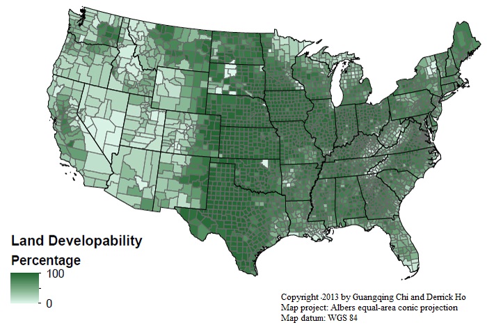
Scholarly researchers, elected officials and land-development experts have a new, comprehensive index at their fingertips to help them identify land available for conversion and/or development.
Demographer Guangqing Chi, an assistant professor of sociology at Mississippi State, is the project leader for the online Land Developability Index that identifies the percentages of lands available and suitable for development in every county and every state in the country.
Located at www.landdevelopability.org, the index allows anyone concerned about land use to determine how much land could be developed at county and state levels. The research is supported by the university's nationally recognized Social Science Research Center and College of Arts and Sciences' department of sociology.
Chi said the tool initially was designed for researchers, but transportation planners, community developers, forestry and natural resource officials, among others, also may benefit.
"The unique thing about this index is that it is just one number representing the overall characteristics and status of land use and development," the University of Wisconsin-Madison doctoral graduate said.
"For people who are interested in land use and development, they can just go online and use it," he added. "There are other projects that share a similar methodology, but they are for different purposes."
The maps were generated using spatial overlay methods on the basis of undevelopable land, such as wetlands, steep slopes, surface water, built-up lands, Native American reservations or federal- or state-owned properties. The index is formatted in ArcGIS shapefiles or Microsoft Excel spreadsheets.
"There are many people who use land use information in their research, but there's so many different variables out there in land use; it could be residential, commercial, forests, Indian reservations or anything else you can think of," Chi explained.
"It takes lots of effort to get all those components together in one data set, one platform," he said. "Users may skip these intermediate steps and simply use the final product of the Land Developability Index."
Chi has been working on the index for approximately a decade. While completing his doctoral studies in environmental demography at Wisconsin, he developed an index for the Badger State to improve population forecasting by accounting for land use and development.
Because so many different factors impact land usage, a comprehensive program needed to be created, he said.
Chi's work has only just begun. He now is planning to refine the index for metropolitan and non-metropolitan areas, municipalities, census tracts, block groups and ZIP codes.
With the overall goal to produce a detailed index for the entire planet, he continues work with assistance from Derrick Ho, a doctoral student in geography at Canada's Simon Fraser University. To expand the index worldwide, however, external funding will be required, Chi said.
At MSU, Chi's team of advisers for the index include Arthur G. Cosby, director of the nationally recognized Social Science Research Center and William L. Giles Distinguished Professor, and sociology professor Robert L. Boyd. Wisconsin-Madison's Stephen J. Ventura, a professor of soil science, and David Levinson, a civil engineering professor at the University of Minnesota, are out-of-state advisers.